By MICHAEL HIDINGER
Contributing Writer
The Albany Bicycle Coalition has proposed an alternative idea for bicycle lanes in the “Traffic Calming” plans for Madison Avenue. The organization’s president Lorenz Worden provided a copy of a
letter they wrote to Coordinator of Traffic Engineering William E. Trudeau on Oct. 14.
The letter explains that “the Albany Bicycle Coalition has considered many different approaches and has concluded that there is only one that maximizes bicyclist safety” and that is separate on-street lanes “with the bicycle lanes widened to six feet to provide a sufficient safety margin.”
The other options proposed for bicycles have been shared lanes in traffic or parking lanes. Separate bike lanes 5-feet-wide have also been discussed, but the Albany Bicycle Coalition’s letter says that “based on our extensive experience, five feet is not sufficient to protect cyclists from car doors, and from wide commercial vehicles parked at the curb.”
The 10th Ward Councilwoman Leah Golby, who represents the Pine Hills neighborhood, said she agrees with Worden on the need for separate bicycle lanes rather than shared lanes that both bicycles and automobiles use. Golby said that she is “one of the daring few” bicyclists to use the shared lanes now found in parts of the city and that the idea of riding in traffic with cars, buses, and trucks scares off many potential cyclists from riding in the city.
“We need to start putting more than one bike lane in the city,” she said.
Golby said she thought that separate bicycle lanes would possibly increase the number of cyclists and reduce the number of cars on the city’s streets and that college students especially might be encouraged to ride bikes rather than drive cars if there were separate lanes.
In 2010, the Albany Common Council passed the Madison Avenue “Traffic Calming” initiative which was followed by a feasibility study. One of the ideas for the “road diet” was to restripe the lanes from four to two. Golby said the study found that the lane reduction was possible and would not slow down traffic as long as traffic lights were changed to synchronize with the new flow of traffic. Golby also said that the Albany Police Department supports the idea of lane reduction and that they believe the plan will make the road safer.
These “traffic calming” plans are the latest developments for a stretch of roadway that has always connected the Pine Hills neighborhood with the rest of the city. At “The Point” intersection where
Madison Avenue meets Western Avenue, there is a long history of different forms of transportation.
Currently there is a CDTA bus stop at “The Point” and there are two bus routes that pass through the area: Route 10 serves Western Avenue and Route 114 serves Madison and Washington avenues. According to the “2012-2013 Route Performance Report” posted on the CDTA website, Route 10 had a total of 875,642 riders with 26.9 riders per hour and Route 114 had 267,579 total riders and 18.7 riders per hour for the 2013 fiscal year.
The area’s history started off much more quietly in contrast to the current heavy volume of traffic.
According to official city historian Tony Opalka, the Pine Hills neighborhood itself developed as a “street car suburb” and that prior to the 1890 establishment of an electric trolley line, the neighborhood was isolated from other parts of the city. The trolley line at that time went to “The Point” intersection. By 1900, it had been extended to the State University and its use was discontinued in 1946.
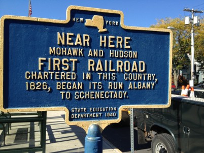
Prior to the electric trolley lines that ran through the neighborhood, “The Point” was the location of the Mohawk and Hudson Railroad station. The trains from this station ran from Albany to Schenectady and back. The historical marker that stands next to the current CDTA bus stop reads, “Near Here Mohawk and Hudson First Railroad Chartered in This Country, 1826, Began Its Run
Albany to Schenectady.” The sign is identified as being produced by the New York State Education Department and is dated 1940.
Though the marker says the railroad station was “near here,” Opalka said that these signs weren’t always entirely accurate and were a product of the “scholarship of the time.”
“I think that was really it, that was the location,” Opalka said.
Railroad Wars of New York State author Timothy Starr said there was another error in the sign.
“The Mohawk and Hudson actually wasn’t the first to be chartered in the country, just the first in New York State,” Starr said.
The opening of the Mohawk and Hudson Railroad brought about direct economic conflict with the then-dominant Erie Canal. The railroad’s route from Albany to Schenectady was faster than traveling through the canal.
“There was definitely conflict at the beginning,” Starr said. “The canal used its influence in the legislature at Albany to put clauses in the railroads’ charters that limited their ability to carry freight as well as pay fees above and beyond the usual taxes.”
Even before the Mohawk and Hudson Railroad connected Albany and Schenectady, the Great Western Turnpike laid down the path that Western Avenue currently follows. Along with Central Avenue, the Great Western Turnpike was one of the main routes west of the city at the time. Both routes were chartered around 1800 by private companies, who charged fees for their use Opalka said.